Summary of the year 2008!!Highlights of the year include wet start to year in January and wet August and December. A rare strong spring storm in May which set the lowest barometric pressure on record with 29.21Hg. A active Monsoon a fairly dry Fall and a wet end to the year!!The year 2008 started out where 2007 end with fairly wet January with several storms passing through the state bringing beneficial rains and mountain snows the biggest storm moved through on Jan 27th with 1.52 inches. Rains continued into early February as the effects of La Nina began to take hold after a wet 3 months which was uncharacteristic of a La Nina year.
In early February a strong cold storm moved through the area producing some rain and mountain snows and coldest night of the winter season of 31.9°F temperatures warm into the 70s by mid month followed by some minor storms and temperatures reach the low 80s by months end for the first time. only 0.50 inches of rain fell. In March the dry weather began to really take hold as mild dry weather prevailed. The dry weather continued in April as the temperatures continued to warm the and the 90°F mark was reach on first time on April 13th. Temperatures remained mild and seasonal for the rest of the month. Early May was warm as the heat began to take hold after a brief windy storm cooled the temperatures back into the mid 70s on the 13th. Then the first heat wave of the early summer began as the century mark (100°F)was reached for the first time on May 18th at: 1:56pm. The heat wave peaked on May 19th with the monthly high temp of 106.8°F. Then a unusally strong late season storm moved into the state and the high temperatures fell into mid 60s by the 23rd. This intense late season strong storm produed the all time record low barometic pressure of 29.21Hg on May 22nd at 3:45 am this unusually strong producef wide spread rain primally in the south and East valley and rarely late season snows in the mountains. Pepperridge record a storm total of 0.11 inches while up to .50 inchesd fell in the East valley during this rare May rain event . In it wake Phoenix experienced a mild Memomial Day weekend with temperatures in the 70s and 80s. Then in early June typical weather prevailed this was followed by a 10day heatwave begining on Jun 14th the heat peaked on June on June 20th with 111.9°F, this was the peak temperature for the year hot temperatures continued until the start of the Monsoon season. Under the new rules the The Monsoon Season began on June 15th but no real storms appeared to early July. The peak wind gust for the year at Pepperridge occured on July 4th with 40mph from a collapsing thunderstorm to our East. The 2008 Monsoon began based on the old method the dewpoint criteria which has to have average 55°F or above for 3 days in a row
This criteria was met on July 5th which means the Monsoon began on July 3rd This years Monsoon was quite active with the first major storm occuring on July 9th and 10th 1.17 inches. Storms continued to be active throughout the season although many missed this location. July had normal precipitation with 1.32 inches. By September thing began to dry out with onyl 0.02 inches falling by months end the official end of the Monsoon, Pepperridge measured 4.19 inches of rain the 4th wetest on record. Sky Harbor usually one of driest areas of town faired much better with 5.70 inches the 10th wetest on record. For the complete Monsoon Highlights Click Here. Warm dry weather continued though the fall with no rain falling October. Early November was warm and dry and this pattern persisted through mid month before the first real storm of the fall season hit on Thanksgiving with welcomed rains. The three day storm which began on November 26th produced 0.64 inches of rain brang the first rainy Thanksgiving Weekend in about 15 years. In fact only 0.10 inches of rain had fallen since Sept 1st prior to the arrival of the first significant storm of the season In December the wetter weather pattern continued with a series of storms on 14th with series of weather systems that moved through the area bringing welcoming valley rain and much needed Mountain Snows. Below normal temperatures continued in the wake of the last in the series of these wet storms that had moved though the area and the high temperatures remained below normal ranging from the high 50s to low 60s through the week before Christmas. Wet weather return on Christmas Day and .40 inches of rain fell over two days as two storms moved through the area. The colder storm arrived on 26th which lowered the snow level to near 3000ft early in the morning as a light dusting of snow fell over the extreme northern fringes of the valley near Carefree. Only rain fell here at Pepperridge with 0.21 inches, but as the skies clear temperatures fell quickly into the 40s and then the mid 30s by midnight on Dec 27th.The temperature fell to 29.8°F on Dec 28th the lowest of the year and this was the first freeze of the winter season, and the first freeze since February. The year ended with slightly warmer temperatures and no rain. In summary the year of 2008 began wet with a Wet January things began to dry in February with little rain falling until a rare late season storm in May. The Monsoon Season was fairly active cummulating with the severe weather outbreak on Aug 28th. Dry weather persisted through the fall and the year ended with wet December. 2008 Highlights:The highest temperature of the year 111.9°F on June 20th at 4:31pm, the lowest temperature of the year 29.8°F on December 27th at 4:36am. The lowest maximum was 50.9°F on December 27th at 2:15pm, and the highest minium was 86.4°F on July 24th at 5:50am and on August 1st at 5:45am. The highest daily average was 97.9°F on August 1st, the lowest mean average was 39.3°F on Dec27th. The high temperature exceded 90°F 153 days this while the low fell to 32°F or below on 4 days. The mean temperature for the year was 71.9°F with a average Humdity of 36% and a average Dewpoint of 40.1°F. Total rainfall for 2008 was 9.68 inches (0.42) inches below normal, and the 6th driest year on record. The greastest daily total was 1.52 inches on January 27th. The wetest month was August with 2.85 inches. The peak wind gust of the year occurred during July with a peak gust of 40 mph on July 4th. Here is a List of other High and Lows recorded in 2008: Highest Dewpoint: 73.8°F on August 29th at 9:50am Highest Humidity 95% on January 28th at 9:19am Highest Barometer reading 30.42inHg on January 10th at 10:48am Highest Wind Gust 40 mph on July 4th at 7:20pm Highest Heat Index 110.1 on August 1st at 2:12pm Below is a summary of the weather year 2008There is also a text box area with more details of records and weather events of the entire year
|
|
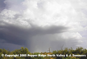 August was a active month with numerous storms effecting parts of the valley the
2nd Decent Storm of Monsoon 2008 at Pepperidge occured on Aug 7th and produced 0.85 inches of rain and a peak Wind Gust of 37 Mph at 9pm. Another good storm occured On Aug 25th with 0.99 inches
a peak Wind Gust of 26 Mph at 7:55pm. But the biggest storm for the valley occured on Aug 28th with the severe weather outbreak Storm this storm produced 0.21 inches rain at Pepperridge with a peak Wind Gust of 37 Mph at 9pm. The Brunt of the storm hit S.E. of this location in Tempe/Mesa and Central Phoenix.
August was a active month with numerous storms effecting parts of the valley the
2nd Decent Storm of Monsoon 2008 at Pepperidge occured on Aug 7th and produced 0.85 inches of rain and a peak Wind Gust of 37 Mph at 9pm. Another good storm occured On Aug 25th with 0.99 inches
a peak Wind Gust of 26 Mph at 7:55pm. But the biggest storm for the valley occured on Aug 28th with the severe weather outbreak Storm this storm produced 0.21 inches rain at Pepperridge with a peak Wind Gust of 37 Mph at 9pm. The Brunt of the storm hit S.E. of this location in Tempe/Mesa and Central Phoenix.