Updated:
31-May-2026 2:55am @
|
 |
The station is located Lat: 33° 39´ 11´´ N | |||||||||
| Time of Next Full Update: 3:00 am - Station Elev: 1469 ft | ||
Weather Links: |
|
 New Feature New Feature |
Celebrating
|

Current Conditions
| @ 31-May-2026 2:55am | |
|
68.6°F
|
|
| Temp Change: | °F /hr |
| Feels Like: | 77 °F |
| Humidity: | 35% |
| Dew Point: | 39.8 °F |
| Wind: | Calm --- mph |
| Gust: | 0.0 mph |
| Pressure: | 29.79 in Steady |
| Solar Rad: | 0% 0 W/m2 |
| UV Index: | 0.0 None |
| Rain Today: | 0.00 in |
| Rain Rate: | 0.000 in |
| Rain Month: | 0.00 in |
| Rain Year: | 0.72 in |
Almanac
| Sunrise: | 5:19 am | |||
| Sunset: | 7:32 pm | |||
| Moonrise: | 7:31 pm | |||
| Moonset: | 5:11 am | |||
|
||||
Daily Min/Max
| Today's High Temp: | 74.0°F 12:00am |
| Today's Low Temp: | 68.6°F 2:53am |
| Today's High Humidity: | 35% 2:54am |
| Today's Low Humidity: | 32% 12:00am |
| Today's High Dewpoint: | 42.3°F 12:00am |
| Today's Low Dewpoint: | 38.7°F 2:40am |
| Today's High Barometric Pressure: | 29.808 in/Hg 12:00am |
| Today's Low Barometric Pressure: | 29.788 in/Hg 2:50am |
| Today's High Wind Speed: | 0.0 mph 12:13pm |
| Today's High UV: |
0.0 None 12:00am |
| Today's High Solar: |
0 W/m2 12:00am |
| Today's High Rain Rate: | 0.000 in/min 12:00am |
| Today's High Hourly Rain Rate: |
0.000 in/hr |
| Days Since Last Rain: |
75 Days |
Member of the:

|
| |
|
|
|
|
|
|

|
|
For more information |
|
 |
|
Return to Top |
|

North America real-time - from the Microferics NetworkMicrosferics Lightning Detection Network, MicroLDN, is a low cost, high accuracy experimental lightning detection network North America near real-time - Vaisala Lightning Explorer
Vaisala Lightning Explorer displays recent lightning activity across the entire continental U.S. The lightning data displayed is North America real-time - Blitzortung Network
This Lightning Map Courtesy of Blitzortung.org hobbyist lightning detection network. | ||||||||||||||||||
Southwest Regional Lightning MapsMicrosferics TOA Lightning NetworkThe TOdA (Time Of difference of Arrival) system is a network based lightning triangulation method Regional mLDN TOA Network 2 hr Lightning Plot
|
6 Hr Lightning time lapse: (Updates every 5 minutes)Hover over for controls (near the center bottom of map) to manually control the Time lapse.
|
Note: Until there are more stations are reporting in Arizona and the Southwest Region strike display is limited.
Own a PWS in the US (especially AZ)? please
Contact the Network if interested in joining.
NOTE: Operating a Boltek Lightning Detection System is no longer required to participate.
|
Disclaimer Note: Remember do not based your outdoor plans or activities solely on the lightning information provided here, this lightning display is for informational purposes only, and not intended to be used, for the protection of life or property. Remember to follow the, Lightning Safety Rules!, especially if thunderstorms are nearby! |
|
|
Additional Live Lightning Links: | |
|
Aninoquisi Lightning Detector Map |
Microsferics Real-Time Lightning - North America
Microsferics Real-Time Lightning - Regional |
Please Stay Safe this Summer and Observe the following;
| |
Southwestern Weather Network - Radar and Lightning!This map displays a view of lightning data and radar - Over the entire Southwestern United States!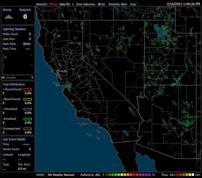
Regional Lightning data/Radar Map Courtesy of Astrogenic
and StrikeStar US. | |
Member of the:
|
|
Page layout last updated on Feb 1st, 2010
Copyright © 2005 - 2026, Pepper Ridge North Valley Weather - All rights reserved .
Unauthorized duplication or distribution is prohibited
Powered By: |
Weather Display vers: 10.37S build: 134 &
WeatherLink 5.71 |
Site Template Designed by: Pali Plumies Designs
Disclaimer:
Never base important decisions on this or any weather information obtained from the Internet.
Number of Visitors Since March 15, 2005