Skip to main content.
Currently:84.9°F Cloudy, Dry
Cloudy, Dry
Comfort Index: ---
 Updated10-Oct-2025 2:25pm @ 
 
Time of Next Full Update: 2:30 pm -  Station Elev: 0 ft  
Pepper Ridge North Valley - Lightning Navigation Menu
Pepper Ridge North Valley - Main Naviagation Menu

Weather Links:

       Home Page 

      Current Weather 

           Forecast Page 

          Historical Data

           Live Lightning 

            Monsoon Info 

        Satellite/Radar 

       Station Info

     Tropical Weather

        Weather Ed. 101 

          Weather Links 

      Weather Photos 

  Weather Warnings

       More Wthr Links 

Us Flag

New FeatureNew Feature
N.O.A.A Radio

Celebrating
20 Years on the web
2005 - 2025

& 25+ Years of Data
1997 - 2025
At Pepper Ridge

 Weather Reports: 
Monsoon 2025New Feature
 Highlights. 

Monsoon 2024
 Highlights. 

Monsoon 2025New Feature
 Wrap Up Review. 

Monsoon 2021
 Wrap Up Review. 


Side Bar Php

Current Conditions

@ 10-Oct-2025 2:25pm
84.9°F Colder 0.2°F than last hour.
Temp Change: °F /hr
Cloudy, Dry  Cloudy, Dry
Feels Like: 87 °F
Humidity: 52
Dew Point: 65.3 °FDecreased 0.2°F since last hour.
Wind: Wind from N N@
3.5 mph
Gust: 0.0 mph
Pressure: 29.85 in Falling 0.025 inHg/hour
Falling slowly
Solar Rad: 36%
230 W/m2
UV Index: 1.2
 Low 
Rain Today: 0.34 in
Rain Rate: 0.000 in
Rain Month: 0.71 in
Rain Year: 10.21 in

Almanac

Sunrise: 6:29 am
Sunset: 6:01 pm
Moonrise: 7:46 pm
Moonset: 10:42 am
Waning Gibbous Moon
Waning Gibbous Moon, Moon age: 18 days,17 hours,8 minutes,83%
83%
Illuminated

Daily Min/Max

Today's High Temp: 88.1°F
12:12pm
Today's Low Temp: 68.9°F
12:00am
Today's High Humidity: 58%
10:08am
Today's Low Humidity: 21%
12:00am
Today's High Dewpoint: 67.9°F
11:49am
Today's Low Dewpoint: 27.3°F
12:00am
Today's High Barometric Pressure: 30.017 in/Hg
2:19am
Today's Low Barometric Pressure: 29.853 in/Hg
2:24pm
Today's High Wind Speed: 17.3 mph
2:07pm
Today's
High UV:
3.8
 Medium 
12:16pm
Today's
High Solar:
664 W/m2
12:19pm
Today's High Rain Rate: 0.029 in/min
1:00am
Today's High
Hourly Rain Rate:
1.714 in/hr
Days Since
Last Rain:
0 Days

Current NWS Alerts:


Yavapai County
  Details for Yavapai County Flash Flood Warning  +2 additional alerts
Gila County
  Details for Gila County Flood Advisory  +2 additional alerts
Central/North Phoenix
  Details for Central/North Phoenix Flood Watch  +1 additional alert
East Valley Phoenix
  Details for East Valley Phoenix Flood Watch  +1 additional alert
West Valley Phoenix
  Details for West Valley Phoenix Flood Watch
Maricopa County
  Details for Maricopa County Flood Watch  +1 additional alert
Pinal County
  Details for Pinal County Flood Watch  +2 additional alerts
Globe/Miami/Superior
  Details for Globe/Miami/Superior Flood Watch
Tucson/Green Valley
  Details for Tucson/Green Valley  Flood Watch
Central Pinal Eloy/Picacho Peak
  Details for Central Pinal Eloy/Picacho Peak Flood Watch
Upper Santa Cruz River Valley & Nogales
  Details for Upper Santa Cruz River Valley & Nogales Flood Watch
Upper San Pedro River Valley & Benson/Sierra Vista
  Details for Upper San Pedro River Valley & Benson/Sierra Vista Flood Watch
Eastern Cochise County & Douglas/Wilcox
  Details for Eastern Cochise County & Douglas/Wilcox Flood Watch
Cochise County
  Details for Cochise County Flood Watch
Santa Cruz County
  Details for Santa Cruz County Flood Watch
Graham/Greenlee Counties
  Details for Graham/Greenlee Counties Flood Watch
Pima County
  Details for Pima County Flood Watch
Yavapai County Valleys & Basins
  Details for Yavapai County Valleys & Basins Flood Watch
Coconino County/Flagstaff & Kaibab Plateau
  Details for Coconino County/Flagstaff & Kaibab Plateau Flood Watch
Oak Creek & Sycamore Canyons
  Details for Oak Creek & Sycamore Canyons Flood Watch
Eastern & Western Mogollon Rim/White Mtns
  Details for Eastern & Western Mogollon Rim/White Mtns Flood Watch
Glen & Marble Canyons/Lake Powell
  Details for Glen & Marble Canyons/Lake Powell Flood Watch
Grand Canyon Country
  Details for Grand Canyon Country Flood Watch
Northwest Deserts/Kingman
  Details for Northwest Deserts/Kingman Flood Watch
Lake Havasu/Fort Mohave & Lake Mead Nat Recreation Area
  Details for Lake Havasu/Fort Mohave & Lake Mead Nat Recreation Area Flood Watch
Yuma/Martinez Lake & Vicinity/Lower Colorado River Valley
  Details for Yuma/Martinez Lake & Vicinity/Lower Colorado River Valley Flood Watch
La Paz County
  Details for La Paz County Flood Watch
Yuma County
  Details for Yuma County Flood Watch

Lower Sidebar Page
Pepper Ridge Weather Station
USA Weather Finder
Wunderground

Sky Warn

CWOP 3794 Quality Control Logo
CW 3794

For more information
about this site
contact the
Web Master

Willow Fire Pyro Cumulus Cloud

Return to Top
of Page

Pepper Ridge North Valley's

Why Thunderstorms Occur In The Summer In Arizona


Back to Monsoon Basics Page


Summer Thunderstorms in Arizona?


Why do Thunderstorms Occur in Arizona During the Summer?

The summer thunderstorm season in Arizona is the northern extension of the Mexican Monsoon. As a result summer rain in Arizona is more variable than across northwest Mexico. Even so, storms in July, August and early September are usually frequent enough to provide a welcome change from the hot, dry days of June.

Where does the moisture for summer thunderstorms in Arizona come from?

There are several moisture sources for thunderstorms in Arizona during the monsoon. The following discussion summarizes the most significant moisture sources for thunderstorms and rain over Arizona.
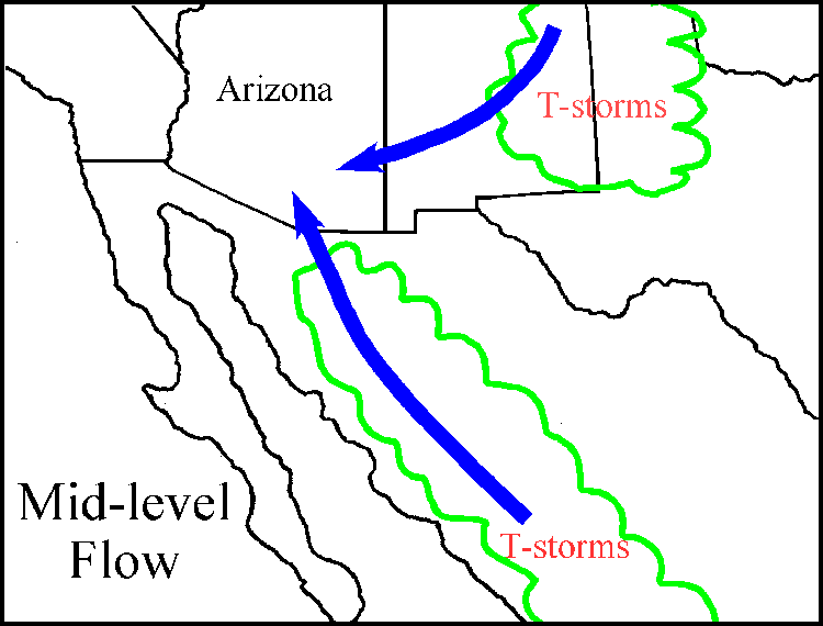
Mid-level moisture is often the earliest moisture to arrive over Arizona during the monsoon. The mid-levels are roughly defined as the layer between 10,000 and 30,000 feet above sea level.

The source for mid-level moisture during the summer is mainly thunderstorms that occur in surrounding regions. The moist remnants of thunderstorms can move into Arizona from the northeast, southeast or south depending on the large-scale flow pattern.

This graphic shows mid-level flow over Arizona


There are several potential sources of low-level moisture over the southern half of Arizona. They include; diurnal flow, Gulf of California moisture surges, thunderstorm outflows, moisture recycling and backdoor fronts.

Diuarnal Flow - The moisture input due to diurnal flow is realtively small in Arizona but increases dramtically further south across northwest Mexico. In general the diurnal surface flow is about 5 to 10 knots from the Gulf of California towards Arizona and the mountain foothills of west and northwest Mexico. This source acts to moisten the low-levels in Arizona but seldom provides enough moisture for significant convective outbreaks. In Mexico the diurnal contribution from the Gulf of California is higher and can enhance developing thunderstorms.

This graphic shows diurnal flow


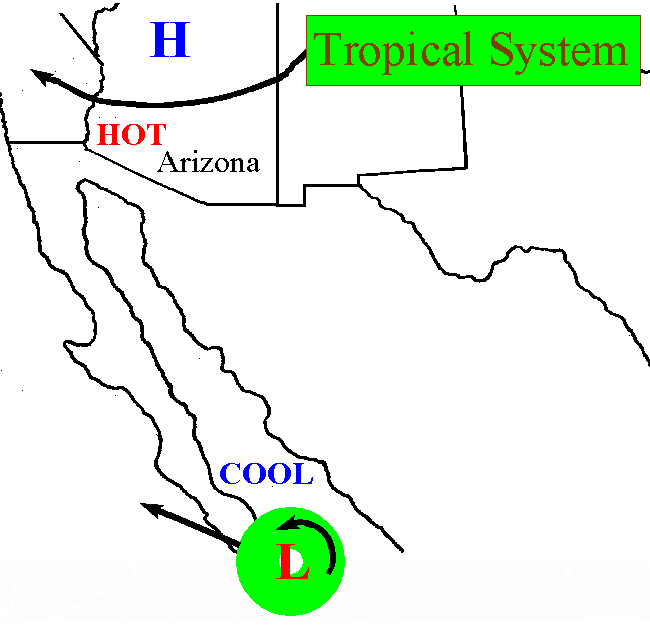
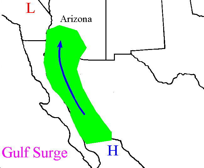
Gulf Surges - Gulf of California moisture surges are a major source of low-level moisture for thunderstorms in Arizona. A Gulf of California surge is a push of low-level moist and cool air that moves northward over the Gulf of California and into southern and Central Arizona. The "Gulf Surge" is such an important player in Arizona monsoon weather a more in-depth presentation is located on the Monsoon Basics Page.

This graphic show a gulf surge


Thunderstorm Outflow - Outflows from thunderstorms also contribute to increasing moisture in Arizona during the monsoon. Each day, during an active monsoon period, thunderstorms develop over the mountains of northwest Mexico and/or Arizona. As these storms release their storage of rain and hail evaporation occurs. This creates cool and moist pockets of air that descend to the ground and move out from the parent thunderstorms. If they are strong enough they can generate new thunder storms in front of the existing storm. Over a series of days the increase in moisture due to outflows can produce a threat of thunderstorms.

This graphic shows thunderstorm outflows


Moisture Recycling - Recycling primarily moistens the low-levels but also provides some moisture at mid-levels due to the depth of desert heating. Moisture recycling occurs when daytime heating causes evaporation at the surface and plant transpiration. The moisture released is mixed upward into the atmosphere. The recycling moisture source is usually in addition to moisture already present and is part of the reason the mountain foothills receive so much more rain than the deserts.

This graphic show moisture recycling


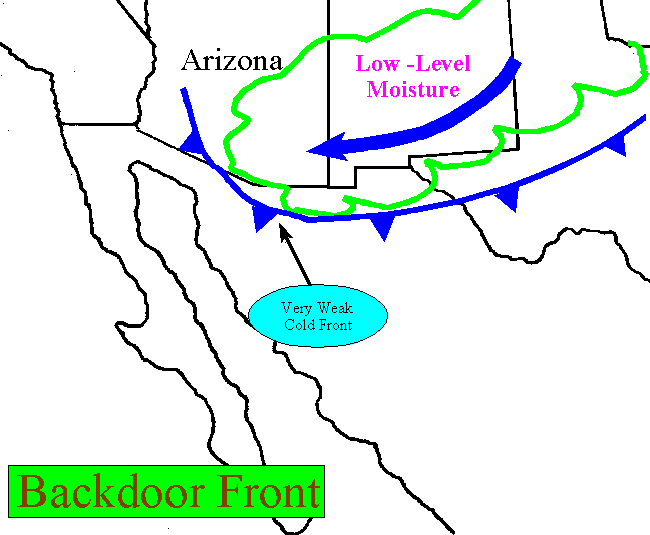
Backdoor Fronts - On occasion, when strong and deep cold fronts form over the High Plains of the United States and move southward along the front range of the Rocky Mountains, they can move across New Mexico and into Arizona. By the time these fronts reach Arizona they are weak but can transport moist low-level air from the High Plains into Arizona. Occasionally enough moisture is present to enhance thunderstorm development over Arizona.

This graphic depicts a back door cold front


What is the character of thunderstorms observed during Arizona's summer thunderstorm season?

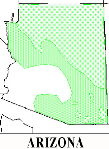
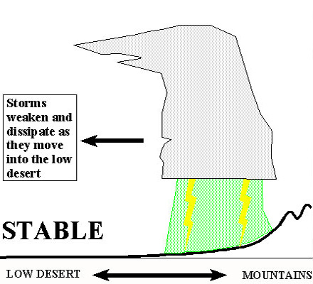
The following examples below depict the different types of thunder storms obsevered on a daily basics during the monsoon. The storms occurance and strengh are highly dependant on the available moisture and the strengh of steering winds that can drive the storms off the mountains and into the deserts.

The strengh of thunderstorms and the amount and coverage of Monsoon thunderstorms can range from low grade, typical or active patterns. On ocassion a tropical connection can enhances the thunderstorms and can lead to wide spread severe weather.

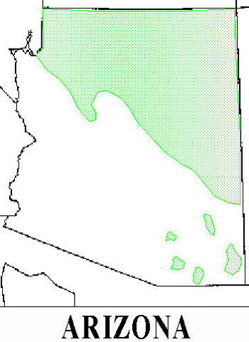
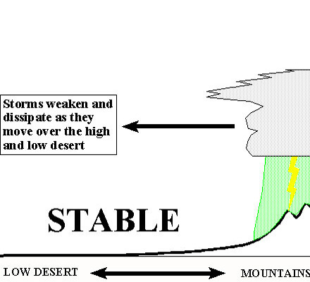
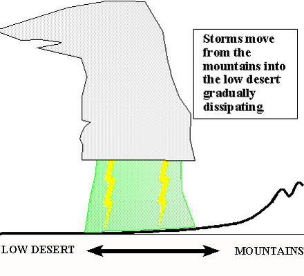
Low Grade Monsoon: - This ocurrs when there is mid-level moisture present across Arizona the high terrain of northern and eastern Arizona can thunderstorms. Storms that form are usually rather benign (except for cloud-to-ground lightning!) and produce little if any significant weather. However, rain amounts of up to half an inch can occur in the mountains. Over a number of days the rainfall totals in the mountains can really add-up. When only mid-level moisture is present it is very difficult for thunderstorms to venture into the desert areas.


This graphic show thunderstomrs over the mountains

This graphic show thunderstomrs over the mountains


Typical Monsoon - Condtions occur when mid-level moisture is present along with an increase in low-level moisture storms will build over the mountains. These storms, while in the mountains, are likely to be stronger and produce more rain than their mid-level moisture counterparts. Since there is more low-level moisture storms are able to move off of the mountains by mid-afternoon and make their way into the high desert. But once again, as these storms move towards the low desert, the air is too dry and stable and they diminish. On days such as this a thunderstorm or two will usually manage to make into Phoenix or Tucson but they then to be weak with only a trace to half inch of rain. On these days Southeastern Arizona and the mountains will see the majority of the thunderstorms.


This graphic shows thunderstorms moving off the mountains

This graphic shows thunderstorms moving off the mountains


Active Monsoon - Is When ample mid-level and low-level moisture is located across Arizona widespread thunderstorm activity is possible. Storms form over the mountains first but head towards the desert area by mid-afternoon. With ample low-levemoisture present storms can become very strong producing a large area of strong wind, heavy rain and frequentcloud-to-ground lightning. Storms can move across the low desert when plenty of low-level moisture is present. In cases of extremely high levels of low-level moisture thundestorms can develop all night, and form into meso- scale convective complexes and move all the way to the California/Arizona border.


This graphic show thunderstorms moving into the valleys

This graphic show thunderstorms moving into the valleys


Tropical Connection - Is a less frequently observed pattern for a Gulf Surge is when a tropical storm or hurricane is located near the southern tip of Baja California. The realtively cool and moist tropical air mass is essentially pushed northward through the Gulf of California. At the same time Arizona is usually experiencing very hot daytime temperatures with a strong thermal low at the surface. This feature is most likely to occur in late season (August or September).

This shows a tropical system patttern


What does a surge look like?

Of course not all Surges are created equal. Some surges are shallow and weak with virtually no affect on Arizona except to increase the humidity. Surges of moderate depth and strength can penetrate all the way into Mogollon Rim country with a distinct upswing in convective activity across Arizona. Occasionally, maybe once or twice a monsoon season, a strong and deep surge will find it's way into Arizona. This is when the real fireworks begin!

A cross section of a surge

Talk about Thunderstorms!

When a strong and deep surge moves across Arizona the fuel for really big storms moves into place. When a big surge passes through Tucson or Phoenix the temperature drops and the humidity skyrockets. It feels like Houston, Texas for a day! Gulf Surges provide the fuel (moisture) responsible for many of the monster thunderstorm complexes that form and ravage the lower desert of Arizona.

Back to monsoon page


Member of the:
LightningRing

Member of the:
World Weather Websites

 Pepper Ridge North Valley Random Weather Facts

WIND CHILL
Wind Chill - The wind chill temperature is what the temperature "feels like" to people and animals during cold weather. Wind chill is based on the rate of heat loss from exposed skin caused by wind and cold. As the wind increases, it draws heat from the body, driving down skin temperature and eventually the internal body temperature. Once temperatures drop below 10 °F and the wind is gusting, conditions are ripe for cold-related illnesses. Below -5 °F, any wind is a major factor in frostbite and hypothermia.

Get the Facts PHP


Page layout last updated on Mar 20th, 2008