Skip to main content.
Currently:84.9°F Mainly cloudy, Dry
Mainly cloudy, Dry
Comfort Index: ---
 Updated10-Oct-2025 2:15pm @ 
 
Time of Next Full Update: 2:20 pm -  Station Elev: 0 ft  
Pepper Ridge North Valley - Navigation Menu
Pepper Ridge North Valley - Main Naviagation Menu

Weather Links:

       Home Page 

      Current Weather 

           Forecast Page 

          Historical Data

           Live Lightning 

            Monsoon Info 

        Satellite/Radar 

       Station Info

     Tropical Weather

        Weather Ed. 101 

          Weather Links 

      Weather Photos 

  Weather Warnings

       More Wthr Links 

Us Flag

New FeatureNew Feature
N.O.A.A Radio

Celebrating
20 Years on the web
2005 - 2025

& 25+ Years of Data
1997 - 2025
At Pepper Ridge

 Weather Reports: 
Monsoon 2025New Feature
 Highlights. 

Monsoon 2024
 Highlights. 

Monsoon 2025New Feature
 Wrap Up Review. 

Monsoon 2021
 Wrap Up Review. 


Lower Sidebar Page
Pepper Ridge Weather Station
USA Weather Finder
Wunderground

Sky Warn

CWOP 3794 Quality Control Logo
CW 3794

For more information
about this site
contact the
Web Master

Willow Fire Pyro Cumulus Cloud

Return to Top
of Page

Welcome to the Pepper Ridge North Valley's
Severe Weather Page

This is your weather warning resource page. Check this page for the latest watches and warning updates, from The National Weather Service, Phoenix, Az.!


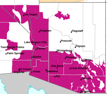
MAP OF CURRENT SOUTHWEST WATCHES, WARNINGS AND ADVISORIES

Current Active Arizona Watches,
Warnings and Advisories

Severe Weather Warnings Map

Phoenix Warnings Flagstaff Warnings Tucson Warnings Las Vegas Warnings

Image credit: NWS, Phoenix, Arizona


Forcasts, Outlooks & Statements:

Short Term Forecast
Special Weather Statement
Flood Statement
Hazardous Weather Outlook

Watches, Warnings & Advisories:

Snow Advisory
Snow And Blowing Snow Advisory
Freezing Rain Advisory
Winter Storm Advisory
Winter Storm Watch
Winter Storm Warning
Heavy Snow Warning
Freeze Watch
Freeze Warning
Wind Advisory
High Wind Watch
High Wind Warning
Heat Advisory
Excessive Heat Warning
Fire Weather Watch
Red Flag Warning
Flash Flood Watch
Flash Flood Warning
Severe ThunderStorm Watch
Severe ThunderStorm Warning
Tornado Watch
Tornado Warning


Local & Regional Weather Statements, Watches And Warnings

Weather Alerts for Cochise County

Issued by the National Weather Service

Flood Watch  FLOOD WATCH   Flood Watch
COCHISE COUNTY

Areas Affected:
Western Pima County Including Ajo/Organ Pipe Cactus National Monument - Tohono O'odham Nation including Sells - Upper Santa Cruz River and Altar Valleys including Nogales - Tucson Metro Area including Tucson/Green Valley/Marana/Vail - South Central Pinal County including Eloy/Picacho Peak State Park - Southeast Pinal County including Kearny/Mammoth/Oracle - Upper San Pedro River Valley including Sierra Vista/Benson - Eastern Cochise County Below 5000 Feet including Douglas/Willcox - Upper Gila River and Aravaipa Valleys including Clifton/Safford - Galiuro and Pinaleno Mountains including Mount Graham - Chiricahua Mountains including Chiricahua National Monument - Dragoon/Mule/Huachuca and Santa Rita Mountains including Bisbee/Canelo Hills/Madera Canyon - Santa Catalina and Rincon Mountains including Mount Lemmon/Summerhaven - Baboquivari Mountains including Kitt Peak
Effective: Fri, 10/10 8:00am Updated: Fri, 10/10 2:15pm Urgency: Future
Expires: Fri, 10/10 4:00pm Severity:  Severe  Certainty: Possible

 
Details:
* WHAT...Flooding caused by excessive rainfall is possible.

* WHERE...A portion of Southeast Arizona, including the following
areas, Baboquivari Mountains, Catalina and Rincon Mountains,
Chiricahua Mountains, Dragoon and Mule and Huachuca and Santa Rita
Mountains, Eastern Cochise County below 5000 feet, Galiuro and
Pinaleno Mountains, South Central Pinal County, Southeast Pinal
County, Tohono O'odham Nation, Tucson Metro Area, Upper Gila River
Valley, Upper San Pedro River Valley, Upper Santa Cruz River
Valley/Altar Valley and Western Pima County.

* WHEN...From Saturday afternoon through Monday afternoon.

* IMPACTS...Excessive runoff may result in flooding of rivers,
creeks, streams, and other low-lying and flood-prone locations.

* ADDITIONAL DETAILS...
- Abundant moisture associated with tropical systems may lead
to a periods of moderate to heavy rainfall and isolated
thunderstorms Saturday afternoon through Monday. Rainfall
totals for the entire 3 day event will range from 1 to 3
inches with isolated higher totals.
- http://www.weather.gov/safety/flood

Information:
You should monitor later forecasts and be alert for possible Flood
Warnings. Those living in areas prone to flooding should be prepared
to take action should flooding develop.


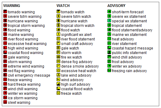
Key to Icons for Local & Regional Weather Statements, Watches And Warnings

Alerts Key

Map of the Current Watches, Warnings, and Advisories Nationwide:

national advisories

Member of the:
LightningRing
World Weather Websites

 North Valley Random Weather Facts

WEATHER NORMALS
What does it really mean when you here the term Normal. Actually a more approriate term is average temp. The National Weather Service currently uses the standard of a 30 year average to determine the "Normal Temperatures and Rainfall". for any given date. This average is adjusted to form a mean curve over any given month, this way the day to day change does not have large variations. Currently N.O.A.A. is using the period of (1970 - 2000) to determine normals.

Get the Facts PHP


Page layout last updated on Mar 8th, 2024