Updated: @19-Jun-2026 5:50am -
Time of next full Update: 5:55 am (See: Real-time Graphs)
Mainly cloudy, Dry
Last Rain: 0.00 .in on: 3/10/2026 -- Consecutive Days Without Rain: 100 Days
Temperature:
76.4°F
Comfort Index:
---
Feels Like:
78
Temp Rate:
/hr
24 Hours Ago:
80.9°F
24 Hour Difference:
-4.6 °F
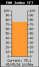
THW Index:
Heat Index:
77.7
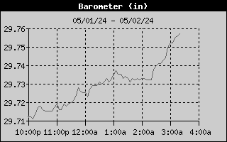
Humidity & Barometer
Humidity:
35%
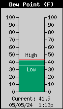
Dewpoint:
46.7 °F
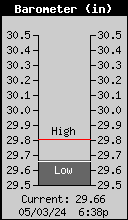
Barometer:
29.81 in
Baro Trend:
Rising slowly
Wind
Wind Direction & Speed:
Calm --- at:
mph
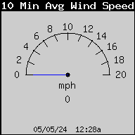
10 Min Wind Average:
0.0 mph
Gusts:
0.0
Peak Gust Last Hr:
0.0 mph
Max Gust Today:
0.0 mph
at: 12:09am
Max Gust this Month:
33.0 mph on: June 15
Current Wind Chill:
76.4
UV Index/Solar Radiation
UV Index:
0.0 None
Solar Radiation:
37 W/m2 (57% of max)
Current Rainfall Data
Today's Rain:
0.00
Today's E.T.
0.01 in
Rain Yesterday:
0.00
Current Rain Rate:
0.000/hr
Today's High Rain Rate:
0.000 in/hr at 5:00pm
Rain in the last 24 hrs:
0.00 in
Monthly Rain Todate:
0.00
Normal Rain Month Todate*:
0.02 in
Rain Year Todate:
0.72
Normal Rain Year Todate*:
0.02 in
Dep. From Normal*:
(0.02) in
Date of Last Rain:
3/10/2026 @
11:13 AM
Days since Last Rain:
100 Days
Today's Weather Extremes
Temperature Extremes
High Temperature:
89.6°F
at: 12:00am
Low Temperature:
75.2°F
at: 5:25am
24 Hour Avg Temp:
92.4°F
Yesterday's High:
103.3°F
at: 4:50pm
Yesterday's Low:
79.8°F
at: 4:33am
Humidity / Dewpoint Extremes
High Humidity:
37%
at: 5:22am
Low Humidity:
24%
at: 12:00am
Average Humidity:
27.5 %
High Dewpoint:
48.6°F
at: 12:46am
Low Dewpoint:
45.1°F at 4:37am
This Month's Extremes
Monthly High Temperature:
108.6°F
on: June 16
Monthly Low Temperature:
69.6°F
on: June 1
Almanac
Sunrise:
5:17 am
Sunset:
7:41 pm
Moonrise:
10:22 am
Moonset:
11:03 pm
UV and Solar Radiation Extremes
High UV Index:
0.0 None at:
12:00am
High Solar Radiation:
37 W/m2
at: 5:49am
Additional Extremes
Daily Low Wind Chill:
75.2°F
at: 5:25am
Daily High Heat Index:
86.4°F
at: 12:00am
Barometer Extremes
High Barometer:
29.812 in/Hg at: 5:49am
Low Barometer:
29.736 in/Hg at:
12:17am
Average Barometer:
29.739 in/Hg
* Normals and Record Extremes are updated daily at 12:00 am MST
Forecast /Moon
Juneteenth
Sunny
Hi 104 °F
Waxing Crescent Moon
23%
Illuminated
6 Hour Histories from the Pepper Ridge North Valley Weather Station
Member of the:
Pepper Ridge North Valley Random Weather Facts
METAR
An Acroymn for METeorological Aerodrome Report. The reports are primarly collected by equipment such as Automated Surface Observing Systems (ASOS). It is the primary weather observation code used in the United States to satisfy requirements for reporting surface meteorological data. Minimum reporting requirements includes wind, visibility, runway visual range, present weather, sky condition, temperature, dew point, and altimeter setting.

 New Feature