Welcome to the Pepper Ridge North Valley's
Severe Weather Page
This is your weather warning resource page. Check this page for the latest watches and warning updates,
from The National Weather Service, Phoenix, Az.!
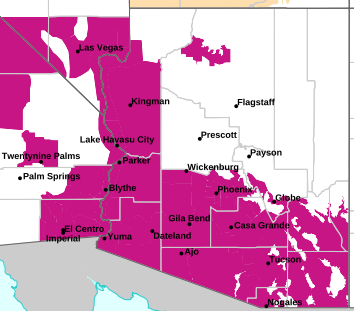
MAP OF CURRENT SOUTHWEST WATCHES, WARNINGS AND ADVISORIES
Local & Regional Weather Statements, Watches And Warnings
Weather Alerts for Pinal CountyIssued by the National Weather Service |
FLOOD WATCH  |
| PINAL COUNTY |
Areas Affected: Upper San Pedro River Valley including Sierra Vista/Benson - Eastern Cochise County Below 5000 Feet including Douglas/Willcox - Upper Gila River and Aravaipa Valleys including Clifton/Safford - Galiuro and Pinaleno Mountains including Mount Graham - Chiricahua Mountains including Chiricahua National Monument - Dragoon/Mule/Huachuca and Santa Rita Mountains including Bisbee/Canelo Hills/Madera Canyon |
| Effective: Thu, 7/16 12:54am |
Updated: Thu, 7/16 3:12am |
Urgency: Future |
| Expires: Thu, 7/16 3:15pm |
Severity: Severe |
Certainty: Possible |
|
Details:
* WHAT...Scattered showers and thunderstorms will be capable of
producing very heavy rain in a short period of time. The excessive
rain will lead to increased chances for flash flooding. The heavy
rain will also lead to significant flow in area washes, creeks, and
rivers.
* WHERE...A portion of Southeast Arizona, including the following
areas, Chiricahua Mountains, Dragoon and Mule and Huachuca and
Santa Rita Mountains, Eastern Cochise County below 5000 feet,
Galiuro and Pinaleno Mountains, Upper Gila River Valley and Upper
San Pedro River Valley.
* WHEN...From 2 PM MST this afternoon until 9 PM MST this evening.
* IMPACTS...Excessive runoff may result in flooding of rivers,
creeks, streams, and other low-lying and flood-prone locations.
* ADDITIONAL DETAILS...
- Daytime heating will combine with a very moist atmosphere to
produce scattered showers and thunderstorms which will be capable
of very heavy rain. Isolated rainfall totals of 1 to 3 inches are
possible.
- http://www.weather.gov/safety/flood
Information:
You should monitor the latest forecast and be alert for possible
Flash Flood Warnings. Those living in areas prone to flooding should
be prepared to take action should flooding develop. |
FLOOD WATCH  |
| PINAL COUNTY |
Areas Affected: Tohono O'odham Nation including Sells - Upper Santa Cruz River and Altar Valleys including Nogales - Tucson Metro Area including Tucson/Green Valley/Marana/Vail - South Central Pinal County including Eloy/Picacho Peak State Park - Southeast Pinal County including Kearny/Mammoth/Oracle - Santa Catalina and Rincon Mountains including Mount Lemmon/Summerhaven - Baboquivari Mountains including Kitt Peak |
| Effective: Thu, 7/16 12:54am |
Updated: Thu, 7/16 3:12am |
Urgency: Future |
| Expires: Thu, 7/16 3:15pm |
Severity: Severe |
Certainty: Possible |
|
Details:
* WHAT...Scattered showers and thunderstorms will be capable of
producing very heavy rain in a short period of time. The excessive
rain will lead to increased chances for flash flooding. The heavy
rain will also lead to significant flow in area washes, creeks, and
rivers.
* WHERE...A portion of Southeast Arizona, including the following
areas, Baboquivari Mountains, Catalina and Rincon Mountains, South
Central Pinal County, Southeast Pinal County, Tohono O'odham
Nation, Tucson Metro Area and Upper Santa Cruz River Valley/Altar
Valley.
* WHEN...From 2 PM MST this afternoon until 5 AM MST Friday morning.
* IMPACTS...Excessive runoff may result in flooding of rivers,
creeks, streams, and other low-lying and flood-prone locations.
* ADDITIONAL DETAILS...
- Daytime heating will combine with a very moist atmosphere to
produce scattered showers and thunderstorms which will be capable
of very heavy rain. Storms will continue after sunset. Isolated
rainfall totals of 1 to 3 inches are possible.
- http://www.weather.gov/safety/flood
Information:
You should monitor the latest forecast and be alert for possible
Flash Flood Warnings. Those living in areas prone to flooding should
be prepared to take action should flooding develop. |
FLOOD WATCH  |
| PINAL COUNTY |
Areas Affected: Aguila Valley - Northwest Valley - Tonopah Desert - Gila Bend - Buckeye/Avondale - Cave Creek/New River - Deer Valley - Central Phoenix - North Phoenix/Glendale - New River Mesa - Scottsdale/Paradise Valley - Rio Verde/Salt River - East Valley - Fountain Hills/East Mesa - South Mountain/Ahwatukee - Southeast Valley/Queen Creek - Superior - Northwest Pinal County - West Pinal County - Apache Junction/Gold Canyon - Tonto Basin - Mazatzal Mountains - Pinal/Superstition Mountains - Sonoran Desert Natl Monument - San Carlos - Dripping Springs - Globe/Miami - Southeast Gila County |
| Effective: Thu, 7/16 12:49am |
Updated: Thu, 7/16 3:12am |
Urgency: Future |
| Expires: Thu, 7/16 3:00pm |
Severity: Severe |
Certainty: Possible |
|
Details:
* WHAT...Flooding caused by excessive rainfall continues to be
possible.
* WHERE...South-central Arizona, including the following areas,
southern Gila County including the city of Globe, Maricopa County
including the Phoenix metropolitan area, and northern Pinal County.
* WHEN...From this afternoon through late tonight.
* IMPACTS...Excessive runoff may result in flooding of rivers,
creeks, streams, and other low-lying and flood-prone locations.
Flooding may occur in poor drainage and urban areas. Low-water
crossings may be flooded.
* ADDITIONAL DETAILS...
- Slow moving thunderstorms and those moving over the same areas
feeding off a high moisture environment may result in rainfall
rates in excess of 2-3"/hr.
- http://www.weather.gov/safety/flood
Information:
You should monitor later forecasts and be alert for possible Flood
Warnings. Those living in areas prone to flooding should be prepared
to take action should flooding develop. |
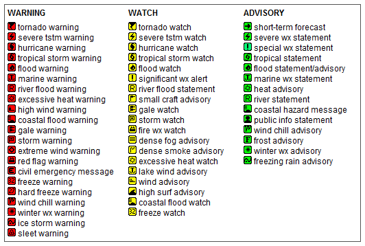
Key to Icons for Local & Regional Weather Statements, Watches And Warnings
Map of the Current Watches, Warnings, and Advisories Nationwide:

|
|
Member of the:

|
North Valley Random Weather Facts |
HEAVY RAIN/FLASH FLOOD In Arizona, typically, the heaviest rain falls during the summer thunderstorm season, or Monsoon, in our state. The rain can accumulate very quickly, resulting in flooded streets or washes, and can even cause deaths via flash flooding. In Phoenix, the greatest rainfall in a 24 hour period was 4.98 inches on July 1-2, 1911. This total is quite a bit less than the Arizona record of 11.4 inches, which fell on Workman Creek (near Globe) on September 4-5, 1970.
Get the Facts PHP
|
|
Page layout last updated on Mar 8th, 2024
|
|
|