Welcome to the Pepper Ridge North Valley's
Severe Weather Page
This is your weather warning resource page. Check this page for the latest watches and warning updates,
from The National Weather Service, Phoenix, Az.!
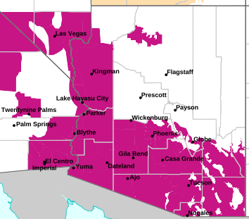
MAP OF CURRENT SOUTHWEST WATCHES, WARNINGS AND ADVISORIES
Local & Regional Weather Statements, Watches And Warnings
Weather Alerts for Santa Cruz CountyIssued by the National Weather Service |
FLOOD WATCH  |
SANTA CRUZ COUNTY |
Areas Affected: Western Pima County Including Ajo/Organ Pipe Cactus National Monument - Tohono O'odham Nation including Sells - Upper Santa Cruz River and Altar Valleys including Nogales - Tucson Metro Area including Tucson/Green Valley/Marana/Vail - South Central Pinal County including Eloy/Picacho Peak State Park - Southeast Pinal County including Kearny/Mammoth/Oracle - Upper San Pedro River Valley including Sierra Vista/Benson - Eastern Cochise County Below 5000 Feet including Douglas/Willcox - Upper Gila River and Aravaipa Valleys including Clifton/Safford - Galiuro and Pinaleno Mountains including Mount Graham - Chiricahua Mountains including Chiricahua National Monument - Dragoon/Mule/Huachuca and Santa Rita Mountains including Bisbee/Canelo Hills/Madera Canyon - Santa Catalina and Rincon Mountains including Mount Lemmon/Summerhaven - Baboquivari Mountains including Kitt Peak |
Effective: Fri, 10/10 8:00am |
Updated: Fri, 10/10 2:26pm |
Urgency: Future |
Expires: Fri, 10/10 4:00pm |
Severity: Severe |
Certainty: Possible |
|
Details:
* WHAT...Flooding caused by excessive rainfall is possible.
* WHERE...A portion of Southeast Arizona, including the following
areas, Baboquivari Mountains, Catalina and Rincon Mountains,
Chiricahua Mountains, Dragoon and Mule and Huachuca and Santa Rita
Mountains, Eastern Cochise County below 5000 feet, Galiuro and
Pinaleno Mountains, South Central Pinal County, Southeast Pinal
County, Tohono O'odham Nation, Tucson Metro Area, Upper Gila River
Valley, Upper San Pedro River Valley, Upper Santa Cruz River
Valley/Altar Valley and Western Pima County.
* WHEN...From Saturday afternoon through Monday afternoon.
* IMPACTS...Excessive runoff may result in flooding of rivers,
creeks, streams, and other low-lying and flood-prone locations.
* ADDITIONAL DETAILS...
- Abundant moisture associated with tropical systems may lead
to a periods of moderate to heavy rainfall and isolated
thunderstorms Saturday afternoon through Monday. Rainfall
totals for the entire 3 day event will range from 1 to 3
inches with isolated higher totals.
- http://www.weather.gov/safety/flood
Information:
You should monitor later forecasts and be alert for possible Flood
Warnings. Those living in areas prone to flooding should be prepared
to take action should flooding develop. |
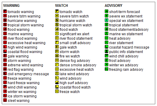
Key to Icons for Local & Regional Weather Statements, Watches And Warnings
Map of the Current Watches, Warnings, and Advisories Nationwide:
|
|
Member of the:

|
North Valley Random Weather Facts |
DEW POINT
Dew point is the temperature to which air must be cooled for saturation (100% relative humidity) to occur. The dew point is an important measurement used to predict the formation of dew, frost, and fog. If dew point and temperature are close together in the late afternoon when the air begins to turn colder, fog is likely during the night. Dew point is also a good indicator of the air's actual water vapor content, unlike relative humidity, which takes the air's temperature into account. High dew point indicates high vapor content; low dew point indicates low vapor content. In addition a high dew point indicates a better chance of rain and severe thunderstorms. You can even use dew point to predict the minimum overnight temperature. Provided no fronts or other weather pattern changes are expected overnight, the afternoon's dew point gives you an idea of what minimum temperature to expect overnight.
Get the Facts PHP
|
|
Page layout last updated on Mar 8th, 2024
|
|
|