Welcome to the Pepper Ridge North Valley's
Severe Weather Page
This is your weather warning resource page. Check this page for the latest watches and warning updates,
from The National Weather Service, Phoenix, Az.!
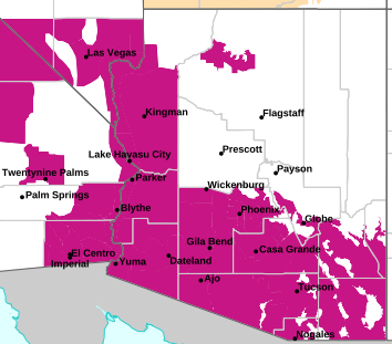
MAP OF CURRENT SOUTHWEST WATCHES, WARNINGS AND ADVISORIES
Local & Regional Weather Statements, Watches And Warnings
Weather Alerts for Cochise CountyIssued by the National Weather Service |
 EXTREME HEAT WARNING EXTREME HEAT WARNING |
| COCHISE COUNTY |
Areas Affected:
Western Pima County Including Ajo/Organ Pipe Cactus National Monument - Tohono O'odham Nation including Sells - Upper Santa Cruz River and Altar Valleys including Nogales - Tucson Metro Area including Tucson/Green Valley/Marana/Vail - South Central Pinal County including Eloy/Picacho Peak State Park - Southeast Pinal County including Kearny/Mammoth/Oracle - Upper San Pedro River Valley including Sierra Vista/Benson - Eastern Cochise County Below 5000 Feet including Douglas/Willcox - Upper Gila River and Aravaipa Valleys including Clifton/Safford |
| Effective: Sat, 8/1 3:17am |
Updated: Sat, 8/1 2:40pm |
Urgency: Expected |
| Expires: Sat, 8/1 5:00pm |
Severity: Severe |
Certainty: Likely |
|
Details:
* WHAT...Dangerously hot conditions with temperatures 101 to 106 in
Santa Cruz and Cochise Counties and 107 to 113 elsewhere. Major to
Extreme HeatRisk is expected.

* WHERE...Eastern Cochise County below 5000 feet, South Central Pinal
County, Southeast Pinal County, Tohono O'odham Nation, Tucson Metro
Area, Upper Gila River Valley, Upper San Pedro River Valley, Upper
Santa Cruz River Valley/Altar Valley, and Western Pima County.

* WHEN...Until 8 PM MST Monday.

* IMPACTS...Heat related illnesses increase significantly during
extreme heat events.

* ADDITIONAL DETAILS...Warm overnight low temperatures of 84 to 90
degrees in the deserts will provide little to no relief from heat
overnight. Warmest overnight low temperatures expected in the
Western Deserts.
Information:
Do not leave young children and pets in unattended vehicles. Car
interiors will reach lethal temperatures in a matter of minutes.

To reduce risk during outdoor work, the Occupational Safety and
Health Administration recommends scheduling frequent rest breaks in
shaded or air conditioned environments. Anyone overcome by heat
should be moved to a cool and shaded location. Heat stroke is an
emergency! Call 9 1 1.

Take extra precautions if you work or spend time outside. When
possible, reschedule strenuous activities to early morning or
evening. Know the signs and symptoms of heat exhaustion and heat
stroke. Wear lightweight and loose fitting clothing when possible and
drink plenty of water. |
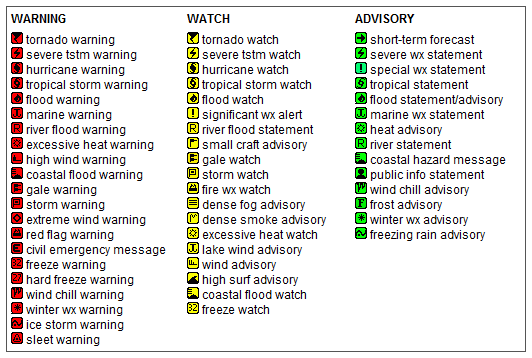
Key to Icons for Local & Regional Weather Statements, Watches And Warnings
Map of the Current Watches, Warnings, and Advisories Nationwide:

|
|
Member of the:


|
North Valley Random Weather Facts |
WEATHER STATION
Weather Station - A weather station is a facility with instruments and equipment to make weather observations by monitoring atmospheric conditions to study the weather. This weather station has a thermometer for measuring temperature; barometer for measuring changes in air pressure; hygrometer for measuring humidity; anemometer for measuring wind speed and wind direction; and rain gauge for measuring precipitation.
Get the Facts PHP
|
|
Page layout last updated on Mar 8th, 2024
|
|
|

 New Feature