Updated:
18-Apr-2026 7:25pm @
|
 |
The station is located Lat: 33° 39´ 11´´ N | |||||||||
| Time of Next Full Update: 7:30 pm - Station Elev: 1469 ft | ||
Weather Links: |
|
 New Feature New Feature |
Celebrating
|
|
| |
|
|
|
|
|
|

|
|
For more information |
|
 |
|
Return to Top |
|
Welcome to Pepper Ridge North Valley'sWeather 101 - Weather Education |
|||||||||||||||||||||||||||||
|
Welcome to Pepperridge North Valley's, Weather 101 - Education pages this new section of our website; includes a Weather Glossary of 1029 weather terms and atmospheric terminology that covers the environmental sciences. This section also includes a webpage that lists the most common cloud types and includes definitions and photos for common cloud formations for easier identification. We also have a in depth explaination of the Arizona Monsoon in this section you will find everything you want to know about the Monsoon Season and summer thunderstorms in the Arizona desert. The goal of this new weather section is to educate persons interested in weather, weather watching and or weather forecasting as a hobby. It is also our goal to educate persons about the basic terms used in Meteorlogy so that they have a better understanding of the field. We hope you enjoy this new addition to our website, and hope you enjoy watching the weather where the variables are in constantly in motion and vary from day to day. Below you will find two examples of the two main sections of weather 101 - the Cloud Types Page and the Weather Glossary |
||
Below is a sample from our Cloud Types PageWhere we include the offical name of the cloud and a picture of it along with a brief description of the weather associated with it's presence | ||
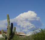
Cumulus Conjestus |
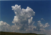
Towering Cumulus |
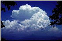
Cumulonimbus with Anvil |
 |
 |
 |
Cumulus Congestus are puffy clouds which are just starting vertical development. Congestus denotes a cloud with active vertical development. These clouds can lead to the development of thunderstorms and cumulonimbus clouds. |
Towering Cumulus is the second stage in the development of a Cumulonimbus cloud. Depending on atmosphere conditions this cloud may mature in a Cumulonimbus cloud or thunderstorm. These cloud have a billowy characteristic with clean sharp edges and a cauiflower shape. As the The top continues to rise, (grow in height), it is most likely composed of ice crystals. |
Cumulonimbus with Anvil - This cloud is most advanced form of the cumulus family. It is a mature storm where the top of the cloud has fanned out and is most likely composed of ice crystals and it is a indicatered of possible severe weather , with Heavy rain , hail, lightning and thunder, and tornados are possible in this savage cloud. |
Base elevation: 1,000 - 2000 feet Top elevation: 10,000 - 15,000 feet |
Base elevation: 3,000 - 5,000 feet Top elevation: 20,000 - 50,000 feet |
Base elevation: 2,000-3,000 feet Top elevation: 40,000 - 60,000 + feet |
So please visit our Cloud Types page for the complete listing of all the most common cloud types and forms, this page includes a cloud chart as well as a listing of clouds base on their obsevered height; High Clouds, Middle Level Clouds, Low Clouds, Low Clouds with Vertical Development and Low Clouds with Precipitation. | ||
Below is a sample from our Weather Glossary PagesThe Glossary includes the name of the weather term, agenceny or phenomenon and a brief to detail description of it occurance and crosslinked references of similar type events |
-S-Saffir-Simpson Scale Damage-Potential Scale - Developed in the early 1970s by Herbert Saffir, a consulting engineer, and Robert Simpson,
then Director of the National Hurricane Center, it is a measure of hurricane intensity on a scale of 1 to 5.
The scale categorizes potential damage based on barometric pressure wind speeds, and storm surge. Saffir-Simpson Scale:
     Cat. 1 Hurricane: Winds 74-95 mph (64-82 kt or 119-153 km/hr). - Moderate Damage.
     Cat. 2 Hurricane: Winds 96-110 mph (83-95 kt or 154-177 km/hr). -  Considerable damage.
     Cat. 3 Hurricane: Winds 111-130 mph (96-113 kt or 178-209 km/hr). - Significant damage.
     Cat. 4 Hurricane: Winds 131-155 mph (114-135 kt or 210-249 km/hr). -  Devastating damage.
     Cat. 5 Hurricane: Winds greater than 155 mph (135 kt or 249 km/hr). - Castrophic damage.
For complete details on the Saffir-Simpson Scale click here. Salinity - A measure of the quantity of dissolved salts in sea water. The total amount of dissolved solids in sea water in parts per thousand by weight. Salt Water - The water of the ocean, distinguished from fresh water by its appreciable salinity. Top-T-*Tower - (Short for towering cumulus), a cloud element showing appreciable upward vertical development. *Towering Cumulus - (Same as congestus.) - A large cumulus cloud with great vertical development, usually with a cauliflower-like appearance, but lacking the characteristic anvil shaped top of a Cb. (Often shortened to "towering cu," and abbreviated TCU.) Top |
|
So Please visit our Weather Glossary page for the complete listing of all the weather terminology In Our Weather Glossary, you will find over 1000 common and uncommon weather definitions, provided by a variety of sources. All the terms are crosslinked, so there's no need to scramble for related definitions. You can search for words (via the links) within their definitions or by scrolling down though the title names on the left. The pages is also searchable by letters links at the top of the pages, also you may search using the links to following sections; Search for Weather Info By the following links:
So if you want to know about vorticity maximums or how fast the winds are in a tornado ranked F3 on the Fujita scale, then our Weather Glossary is for you. |
||
Page layout last updated on Mar 7th, 2008

