Skip to main content.
Currently:100.6°F Sunny, Dry
Sunny, Dry
Comfort Index: ---
 Updated06-Aug-2026 2:15pm @ 
 
Time of Next Full Update: 2:20 pm -  Station Elev: 1469 ft  
Pepper Ridge North Valley - Navigation Menu
Pepper Ridge North Valley - Main Naviagation Menu

Weather Links:

       Home Page 

      Current Weather 

           Forecast Page 

          Historical Data

           Live Lightning 

            Monsoon Info 

        Satellite/Radar 

       Station Info

     Tropical Weather

        Weather Ed. 101 

          Weather Links 

      Weather Photos 

  Weather Warnings

       More Wthr Links 

Us Flag

New FeatureNew Feature
N.O.A.A Radio

Celebrating
20 Years on the web
2005 - 2025

& 25+ Years of Data
1997 - 2025
At Pepper Ridge

 Weather Reports: 
Monsoon 2025New Feature
 Highlights. 

Monsoon 2024
 Highlights. 

Monsoon 2025New Feature
 Wrap Up Review. 

Monsoon 2021
 Wrap Up Review. 


Lower Sidebar Page
Pepper Ridge Weather Station
USA Weather Finder
Wunderground

Sky Warn

CWOP 3794 Quality Control Logo
CW 3794

For more information
about this site
contact the
Web Master

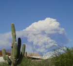
Willow Fire Pyro Cumulus Cloud

Return to Top
of Page

Welcome to the Pepper Ridge North Valley's
Severe Weather Page

This is your weather warning resource page. Check this page for the latest watches and warning updates, from The National Weather Service, Phoenix, Az.!


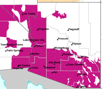
MAP OF CURRENT SOUTHWEST WATCHES, WARNINGS AND ADVISORIES

Current Active Arizona Watches,
Warnings and Advisories

Severe Weather Warnings Map

Phoenix Warnings Flagstaff Warnings Tucson Warnings Las Vegas Warnings

Image credit: NWS, Phoenix, Arizona


Forcasts, Outlooks & Statements:

Short Term Forecast
Special Weather Statement
Flood Statement
Hazardous Weather Outlook

Watches, Warnings & Advisories:

Snow Advisory
Snow And Blowing Snow Advisory
Freezing Rain Advisory
Winter Storm Advisory
Winter Storm Watch
Winter Storm Warning
Heavy Snow Warning
Freeze Watch
Freeze Warning
Wind Advisory
High Wind Watch
High Wind Warning
Heat Advisory
Excessive Heat Warning
Fire Weather Watch
Red Flag Warning
Flash Flood Watch
Flash Flood Warning
Severe ThunderStorm Watch
Severe ThunderStorm Warning
Tornado Watch
Tornado Warning


Local & Regional Weather Statements, Watches And Warnings
Weather Alerts for Maricopa County

Issued by the National Weather Service

Extreme Heat Warning  EXTREME HEAT WARNING   Extreme Heat Warning
MARICOPA COUNTY

Areas Affected:
Aguila Valley - Tonopah Desert - Gila Bend - Cave Creek/New River - Fountain Hills/East Mesa - Northwest Pinal County - West Pinal County - Apache Junction/Gold Canyon - Sonoran Desert Natl Monument
Effective: Thu, 8/6 11:48am Updated: Thu, 8/6 2:14pm Urgency: Expected
Expires: Fri, 8/7 3:30am Severity:  Severe  Certainty: Likely

 
Details:
* WHAT...Dangerously hot and humid conditions. Afternoon temperatures
106 to 116 degrees. Major Heat Risk.

* WHERE...Portions of Maricopa and Northern Pinal counties

* WHEN...Until 8 PM MST Sunday.

* IMPACTS...Heat related illnesses increase significantly during
extreme heat events. Overexposure can cause heat cramps and heat
exhaustion to develop and, without intervention, can lead to heat
stroke.

* ADDITIONAL DETAILS...In Maricopa County, Call 2-1-1 to find a free
cooling center, transportation, water and more.
https://www.maricopa.gov/heat

Information:
An Extreme Heat Warning means that a period of very hot temperatures,
even by local standards, will occur. Actions should be taken to
lessen the impact of the extreme heat.

Take extra precautions if you work or spend time outside. When
possible, reschedule strenuous activities to early morning or
evening. Know the signs and symptoms of heat exhaustion and heat
stroke. Wear lightweight and loose-fitting clothing when possible and
drink plenty of water.

To reduce risk during outdoor work, the Occupational Safety and
Health Administration recommends scheduling frequent rest breaks in
shaded or air conditioned environments. Anyone overcome by heat
should be moved to a cool and shaded location. Heat stroke is an
emergency! Call 9 1 1.

Public cooling shelters are available in some areas. Consult county
officials for more details.

Extreme Heat Warning  EXTREME HEAT WARNING   Extreme Heat Warning
MARICOPA COUNTY

Areas Affected:
Northwest Valley - Buckeye/Avondale - Deer Valley - Central Phoenix - North Phoenix/Glendale - Scottsdale/Paradise Valley - East Valley - South Mountain/Ahwatukee - Southeast Valley/Queen Creek
Effective: Thu, 8/6 11:48am Updated: Thu, 8/6 2:14pm Urgency: Expected
Expires: Fri, 8/7 3:30am Severity:  Severe  Certainty: Likely

 
Details:
* WHAT...Dangerously hot and humid conditions. Afternoon temperatures
108 to 114 degrees. Major Heat Risk.

* WHERE...The Phoenix metropolitan area.

* WHEN...Until 8 PM MST Sunday.

* IMPACTS...Heat related illnesses increase significantly during
extreme heat events. Overexposure can cause heat cramps and heat
exhaustion to develop and, without intervention, can lead to heat
stroke.

* ADDITIONAL DETAILS...In Maricopa County, Call 2-1-1 to find a free
cooling center, transportation, water and more.
https://www.maricopa.gov/heat

Information:
An Extreme Heat Warning means that a period of very hot temperatures,
even by local standards, will occur. Actions should be taken to
lessen the impact of the extreme heat.

Take extra precautions if you work or spend time outside. When
possible, reschedule strenuous activities to early morning or
evening. Know the signs and symptoms of heat exhaustion and heat
stroke. Wear lightweight and loose-fitting clothing when possible and
drink plenty of water.

To reduce risk during outdoor work, the Occupational Safety and
Health Administration recommends scheduling frequent rest breaks in
shaded or air conditioned environments. Anyone overcome by heat
should be moved to a cool and shaded location. Heat stroke is an
emergency! Call 9 1 1.

Public cooling shelters are available in some areas. Consult county
officials for more details.

Air Quality Alert  AIR QUALITY ALERT   Air Quality Alert
MARICOPA COUNTY

Areas Affected:
Maricopa, AZ
Effective: Thu, 8/6 9:42am Updated: Thu, 8/6 2:14pm Urgency: Unknown
Expires: Thu, 8/6 9:00pm Severity: Unknown Certainty: Unknown

 
Details:
AQAPSR

The Arizona Department of Environmental Quality (ADEQ) has issued a
PM-10 High Pollution Advisory for the Phoenix Metro Area today.

Lingering dust from last night has resulted in high local PM-10
concentrations that pose a health risk. Adverse health effects
increase as air quality deteriorates.

Coarse particulate matter - also known as PM-10 - is an air
contaminant that can aggravate heart and lung disease conditions,
especially in older adults, children, and those with asthma. A
decrease in physical activity is recommended.

Consolidate your travel, stabilize loose soils, slow down or avoid
travel on dirt roads, reduce or eliminate fireplace use, and avoid
using gas-powered lawn equipment.

For details on this High Pollution Advisory, visit the ADEQ internet
site at www.azdeq.gov/forecast/phoenix or call 602-771-2300.


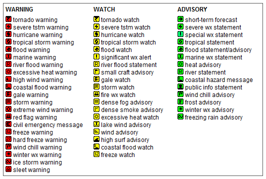
Key to Icons for Local & Regional Weather Statements, Watches And Warnings

Alerts Key

Map of the Current Watches, Warnings, and Advisories Nationwide:

national advisories

Member of the:
LightningRing
World Weather Websites

 North Valley Random Weather Facts

RAINFALL
Terms such as "slight chance" of rain (10-20%), "chance" of rain (30-50%) or rain "likely" (60-70%) are used when there is uncertainty of receiving measurable precipitation anywhere in the forecast area (such as the Greater Phoenix Area). For instance, if there is only a 30-50 percent chance that rain will fall anywhere in the Phoenix Metro area, then the forecast will call for a "chance" of rain.

Get the Facts PHP


Page layout last updated on Mar 8th, 2024