Welcome to the Pepper Ridge North Valley's
Severe Weather Page
This is your weather warning resource page. Check this page for the latest watches and warning updates,
from The National Weather Service, Phoenix, Az.!
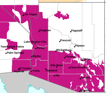
MAP OF CURRENT SOUTHWEST WATCHES, WARNINGS AND ADVISORIES
Local & Regional Weather Statements, Watches And Warnings
Weather Alerts for Glen & Marble Canyons/Lake PowellIssued by the National Weather Service |
 FLOOD WATCH FLOOD WATCH |
| GLEN & MARBLE CANYONS/LAKE POWELL |
Areas Affected:
Kaibab Plateau - Marble and Glen Canyons - Grand Canyon Country - Coconino Plateau - Yavapai County Mountains - Northeast Plateaus and Mesas Hwy 264 Northward - Chinle Valley - Chuska Mountains and Defiance Plateau - Little Colorado River Valley in Coconino County - Little Colorado River Valley in Navajo County - Little Colorado River Valley in Apache County - Western Mogollon Rim - Eastern Mogollon Rim - White Mountains - Northern Gila County - Yavapai County Valleys and Basins - Oak Creek and Sycamore Canyons - Black Mesa Area - Northeast Plateaus and Mesas South of Hwy 264 |
| Effective: Sat, 9/26 12:01pm |
Updated: Sat, 9/26 3:37pm |
Urgency: Future |
| Expires: Mon, 9/28 11:45pm |
Severity: Severe |
Certainty: Possible |
|
Details:
* WHAT...Flooding caused by excessive and long duration rainfall.

* WHERE...All of northern and central Arizona.

* WHEN...From Sunday evening through Tuesday evening.

* IMPACTS...Flooding will be possible over burn areas, low-water
crossings, creeks, streams, washes and swimming holes. Larger
creeks and rivers may exceed bankfull. Flooding of paved roads and
highway underpasses will be possible. Unpaved roads could become
muddy and impassable.

* ADDITIONAL DETAILS...
- Low pressure will interact with tropical moisture from the
eastern Pacific. This could potentially produce numerous showers
and embedded thunderstorms, with heavy rain that will fall over
saturated soils and burn scars. This could lead to localized
flash flooding and rises on local rivers, such as the Little
Colorado River.
- Additional information is available at weather.gov/flagstaff.
Information:
You should monitor later forecasts and be alert for possible Flood
Warnings. Those living in areas prone to flooding should be prepared
to take action should flooding develop. |
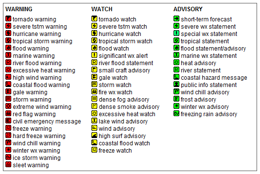
Key to Icons for Local & Regional Weather Statements, Watches And Warnings
Map of the Current Watches, Warnings, and Advisories Nationwide:

|
|
Member of the:


|
North Valley Random Weather Facts |
BAROMETRIC PRESSURE
The air that makes up our atmosphere exerts a pressure
on the surface of the earth. This pressure is known as atmospheric pressure. It is measured in inches/Hg. Generally, the more air above an area, the higher the atmospheric pressure. Barometric pressure changes with local weather conditions, making barometric pressure an important and useful weather forecasting tool. High pressure zones are generally associated with fair weather, while low pressure zones are generally associated with poor weather.
For forecasting purposes, the absolute barometric pressure value is generally less important than the change in barometric pressure. In general, rising pressure indicates improving weather conditions, while falling pressure indicates deteriorating weather conditions.
Get the Facts PHP
|
|
Page layout last updated on Mar 8th, 2024
|
|
|


 New Feature