Welcome to the Pepper Ridge North Valley's
Severe Weather Page
This is your weather warning resource page. Check this page for the latest watches and warning updates,
from The National Weather Service, Phoenix, Az.!
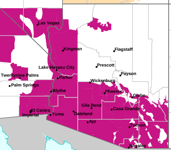
MAP OF CURRENT SOUTHWEST WATCHES, WARNINGS AND ADVISORIES
Local & Regional Weather Statements, Watches And Warnings
Weather Alerts for Eastern & Western Mogollon Rim/White MtnsIssued by the National Weather Service |
 FLOOD WATCH FLOOD WATCH |
| EASTERN & WESTERN MOGOLLON RIM/WHITE MTNS |
Areas Affected:
Western Pima County Including Ajo/Organ Pipe Cactus National Monument - Tohono O'odham Nation including Sells - Upper Santa Cruz River and Altar Valleys including Nogales - Tucson Metro Area including Tucson/Green Valley/Marana/Vail - South Central Pinal County including Eloy/Picacho Peak State Park - Southeast Pinal County including Kearny/Mammoth/Oracle - Upper San Pedro River Valley including Sierra Vista/Benson - Eastern Cochise County Below 5000 Feet including Douglas/Willcox - Upper Gila River and Aravaipa Valleys including Clifton/Safford - White Mountains of Graham and Greenlee Counties including Hannagan Meadow - Galiuro and Pinaleno Mountains including Mount Graham - Chiricahua Mountains including Chiricahua National Monument - Dragoon/Mule/Huachuca and Santa Rita Mountains including Bisbee/Canelo Hills/Madera Canyon - Santa Catalina and Rincon Mountains including Mount Lemmon/Summerhaven - Baboquivari Mountains including Kitt Peak |
| Effective: Tue, 9/15 6:47pm |
Updated: Wed, 9/16 2:26am |
Urgency: Future |
| Expires: Wed, 9/16 5:00am |
Severity: Severe |
Certainty: Possible |
|
Details:
* WHAT...Flooding caused by excessive rainfall continues to be
possible.

* WHERE...A portion of Southeast Arizona, including the following
areas, Baboquivari Mountains, Catalina and Rincon Mountains,
Chiricahua Mountains, Dragoon and Mule and Huachuca and Santa Rita
Mountains, Eastern Cochise County below 5000 feet, Galiuro and
Pinaleno Mountains, South Central Pinal County, Southeast Pinal
County, Tohono O'odham Nation, Tucson Metro Area, Upper Gila River
Valley, Upper San Pedro River Valley, Upper Santa Cruz River
Valley/Altar Valley, Western Pima County and White Mountains of
Graham and Greenlee Counties.

* WHEN...From 11 PM MST this evening through Wednesday evening.

* IMPACTS...Excessive runoff may result in flooding of rivers,
creeks, streams, and other low-lying and flood-prone locations.
Creeks and streams may rise out of their banks. Flooding may occur
in poor drainage and urban areas. Low-water crossings may be
flooded.

* ADDITIONAL DETAILS...
- Well above normal moisture levels for September are expected to
result in scattered to numerous showers and thunderstorms capable
of producing heavy rainfall from late tonight through late
tomorrow night. Rain totals of 1 to 2 inches are expected with
the stronger storms with isolated amounts over 2 inches possible.
Areas that received substantial rainfall over the previous few
days will be more susceptible to flash flooding. This rainfall
will result in faster response in washes, creeks, and storm
drainages.
- http://www.weather.gov/safety/flood
Information:
You should monitor later forecasts and be alert for possible Flood
Warnings. Those living in areas prone to flooding should be prepared
to take action should flooding develop. |
| FLOOD WATCH |
| EASTERN & WESTERN MOGOLLON RIM/WHITE MTNS |
Areas Affected:
Kaibab Plateau - Marble and Glen Canyons - Grand Canyon Country - Coconino Plateau - Yavapai County Mountains - Northeast Plateaus and Mesas Hwy 264 Northward - Chinle Valley - Chuska Mountains and Defiance Plateau - Little Colorado River Valley in Coconino County - Little Colorado River Valley in Navajo County - Little Colorado River Valley in Apache County - Western Mogollon Rim - Eastern Mogollon Rim - White Mountains - Northern Gila County - Yavapai County Valleys and Basins - Oak Creek and Sycamore Canyons - Black Mesa Area - Northeast Plateaus and Mesas South of Hwy 264 |
| Effective: Tue, 9/15 10:56pm |
Updated: Wed, 9/16 2:26am |
Urgency: Future |
| Expires: Thu, 9/17 5:00am |
Severity: Severe |
Certainty: Possible |
|
Details:
* WHAT...Flash flooding caused by excessive rainfall continues to be
possible.

* WHERE...Portions of east central, north central, northeast, and
west central Arizona, including the following areas, in east
central Arizona, Northern Gila County. In north central Arizona,
Black Mesa Area, Coconino Plateau, Eastern Mogollon Rim, Grand
Canyon Country, Kaibab Plateau, Little Colorado River Valley in
Coconino County, Marble and Glen Canyons, Northeast Plateaus and
Mesas Hwy 264 Northward, Northeast Plateaus and Mesas South of Hwy
264 and Western Mogollon Rim. In northeast Arizona, Chinle Valley,
Chuska Mountains and Defiance Plateau, Little Colorado River Valley
in Apache County, Little Colorado River Valley in Navajo County and
White Mountains. In west central Arizona, Oak Creek and Sycamore
Canyons, Yavapai County Mountains and Yavapai County Valleys and
Basins.

* WHEN...Through late Wednesday night.

* IMPACTS...Flash flooding will be possible in creeks, normally dry
washes, swimming holes, and over recently burned areas.

* ADDITIONAL DETAILS...
- Increasing moisture will combine with a shortwave feature moving
north across Arizona to bring multiple rounds of showers and
thunderstorms from late Tuesday night through Wednesday night.
Thunderstorms will have the potential to produce heavy rainfall
that could lead to flash flooding, especially in areas that
receive repeated rounds of rainfall.
- Additional information is available at weather.gov/flagstaff.
Information:
Have a way to receive Flash Flood Warnings and be prepared to take
action should warnings be issued. |
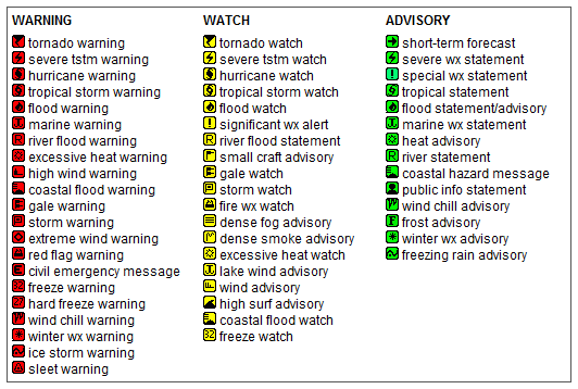
Key to Icons for Local & Regional Weather Statements, Watches And Warnings
Map of the Current Watches, Warnings, and Advisories Nationwide:

|
|
Member of the:


|
North Valley Random Weather Facts |
HUMIDEX
Definition Humidex - Over the years, several measures have been proposed to relate various combinations of temperature and humidity into a single number to approximate what hot, humid weather feels like to the average person. Of these, humidex is the one most familiar to Canadians. Humidex was introduced into Canada in 1965. The index is a summer analogue of the wind chill factor in that it is an equivalent air temperature. Air of a given temperature and humidity is equated in comfort to air of a higher temperature that has a negligible moisture content. Comfort is quite subjective and largely dependent on the age and health of the individual. Weather conditions causing prickly heat in an infant may result in heat cramps in a teenager, heat exhaustion in a middle-aged and heat stroke in a senior. Humidex is also limited as an overall hot-weather comfort index because it does not consider other factors such as pressure, wind speed, precipitation, sunshine or pollen.
Get the Facts PHP
|
|
Page layout last updated on Mar 8th, 2024
|
|
|


 New Feature