Welcome to the Pepper Ridge North Valley's
Severe Weather Page
This is your weather warning resource page. Check this page for the latest watches and warning updates,
from The National Weather Service, Phoenix, Az.!
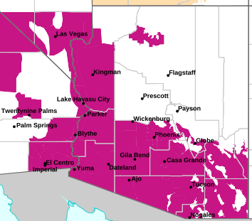
MAP OF CURRENT SOUTHWEST WATCHES, WARNINGS AND ADVISORIES
Local & Regional Weather Statements, Watches And Warnings
Weather Alerts for Upper San Pedro River Valley & Benson/Sierra VistaIssued by the National Weather Service |
EXTREME HEAT WARNING  |
| UPPER SAN PEDRO RIVER VALLEY & BENSON/SIERRA VISTA |
Areas Affected: Upper Santa Cruz River and Altar Valleys including Nogales - Tucson Metro Area including Tucson/Green Valley/Marana/Vail - Upper San Pedro River Valley including Sierra Vista/Benson - Eastern Cochise County Below 5000 Feet including Douglas/Willcox - Upper Gila River and Aravaipa Valleys including Clifton/Safford |
| Effective: Mon, 8/3 2:06pm |
Updated: Mon, 8/3 2:48pm |
Urgency: Expected |
| Expires: Mon, 8/3 8:00pm |
Severity: Severe |
Certainty: Likely |
|
Details:
* WHAT...Thunderstorms will initially develop over the Mogollon Rim
and other sky islands of Southeast Arizona, then track southwest
into the valleys of Southeast Arizona and become widespread during
the late afternoon, then move across the lower deserts of Southeast
Arizona through the evening. The stronger storms will produce
organized thunderstorm outflow winds between 45-55 mph, resulting
in dense blowing dust with visibility between one-quarter and
one-half mile and possibly a haboob with near-zero visibility. For
the Extreme Heat Warning, dangerously hot conditions with
temperatures 101 to 106. Major to Extreme HeatRisk is expected.
* WHERE...Eastern Cochise County below 5000 feet, Tucson Metro Area,
Upper Gila River Valley, Upper San Pedro River Valley, and Upper
Santa Cruz River Valley/Altar Valley.
* WHEN...Until 8 PM MST this evening.
* IMPACTS...Hazardous driving conditions due to reduced visibility.
Heat related illnesses increase significantly during extreme heat
events.
Information:
Persons with respiratory problems should make preparations to stay
indoors until the storm passes. Be ready for a sudden drop in
visibility to near zero. If you encounter blowing dust or blowing
sand on the roadway or see it approaching, pull off the road as far
as possible and put your vehicle in park. Turn the lights all the way
off and keep foot off the brake pedal. Remember, 'Pull Aside, Stay
Alive'.
Do not leave young children and pets in unattended vehicles. Car
interiors will reach lethal temperatures in a matter of minutes.
Take extra precautions when outside. Wear lightweight and loose
fitting clothing. Try to limit strenuous activities to early morning
or evening. Take action when you see symptoms of heat exhaustion and
heat stroke.
Take extra precautions if you work or spend time outside. When
possible, reschedule strenuous activities to early morning or
evening. Know the signs and symptoms of heat exhaustion and heat
stroke. Wear lightweight and loose fitting clothing when possible and
drink plenty of water. |
BLOWING DUST ADVISORY  |
| UPPER SAN PEDRO RIVER VALLEY & BENSON/SIERRA VISTA |
Areas Affected: Upper Santa Cruz River and Altar Valleys including Nogales - Tucson Metro Area including Tucson/Green Valley/Marana/Vail - Upper San Pedro River Valley including Sierra Vista/Benson - Eastern Cochise County Below 5000 Feet including Douglas/Willcox - Upper Gila River and Aravaipa Valleys including Clifton/Safford |
| Effective: Mon, 8/3 2:06pm |
Updated: Mon, 8/3 2:48pm |
Urgency: Expected |
| Expires: Mon, 8/3 8:00pm |
Severity: Moderate |
Certainty: Likely |
|
Details:
* WHAT...Thunderstorms will initially develop over the Mogollon Rim
and other sky islands of Southeast Arizona, then track southwest
into the valleys of Southeast Arizona and become widespread during
the late afternoon, then move across the lower deserts of Southeast
Arizona through the evening. The stronger storms will produce
organized thunderstorm outflow winds between 45-55 mph, resulting
in dense blowing dust with visibility between one-quarter and
one-half mile and possibly a haboob with near-zero visibility. For
the Extreme Heat Warning, dangerously hot conditions with
temperatures 101 to 106. Major to Extreme HeatRisk is expected.
* WHERE...Eastern Cochise County below 5000 feet, Tucson Metro Area,
Upper Gila River Valley, Upper San Pedro River Valley, and Upper
Santa Cruz River Valley/Altar Valley.
* WHEN...Until 8 PM MST this evening.
* IMPACTS...Hazardous driving conditions due to reduced visibility.
Heat related illnesses increase significantly during extreme heat
events.
Information:
Persons with respiratory problems should make preparations to stay
indoors until the storm passes. Be ready for a sudden drop in
visibility to near zero. If you encounter blowing dust or blowing
sand on the roadway or see it approaching, pull off the road as far
as possible and put your vehicle in park. Turn the lights all the way
off and keep foot off the brake pedal. Remember, 'Pull Aside, Stay
Alive'.
Do not leave young children and pets in unattended vehicles. Car
interiors will reach lethal temperatures in a matter of minutes.
Take extra precautions when outside. Wear lightweight and loose
fitting clothing. Try to limit strenuous activities to early morning
or evening. Take action when you see symptoms of heat exhaustion and
heat stroke.
Take extra precautions if you work or spend time outside. When
possible, reschedule strenuous activities to early morning or
evening. Know the signs and symptoms of heat exhaustion and heat
stroke. Wear lightweight and loose fitting clothing when possible and
drink plenty of water. |
FLOOD WATCH  |
| UPPER SAN PEDRO RIVER VALLEY & BENSON/SIERRA VISTA |
Areas Affected: Upper Santa Cruz River and Altar Valleys including Nogales - Tucson Metro Area including Tucson/Green Valley/Marana/Vail - Upper San Pedro River Valley including Sierra Vista/Benson - Dragoon/Mule/Huachuca and Santa Rita Mountains including Bisbee/Canelo Hills/Madera Canyon - Baboquivari Mountains including Kitt Peak |
| Effective: Mon, 8/3 2:10pm |
Updated: Mon, 8/3 2:48pm |
Urgency: Future |
| Expires: Mon, 8/3 10:00pm |
Severity: Severe |
Certainty: Possible |
|
Details:
* WHAT...Flash flooding caused by excessive rainfall is possible.
* WHERE...A portion of south-central Arizona, including Santa Cruz,
southwest Cochise and south-central and southeast Pima counties.
* WHEN...Until 10 PM MST this evening.
* IMPACTS...Excessive rainfall runoff may result in flash flooding of
normally dry washes, roadway dips and other low-lying areas.
* ADDITIONAL DETAILS...
- The combination of an increase in lower-level moisture and an
favorable weather pattern will result in widespread strong
thunderstorms with heavy rain across portions of south- central
Arizona. Although most areas impacted by thunderstorms will
receive only between one half to one inch of rain, isolated
locations may receive between 1 and 3 inches. Excessive rainfall
runoff will result in flash flooding.
- Http://www.weather.gov/safety/flood
Information:
You should monitor later forecasts and be prepared to take action
should Flash Flood Warnings be issued. |
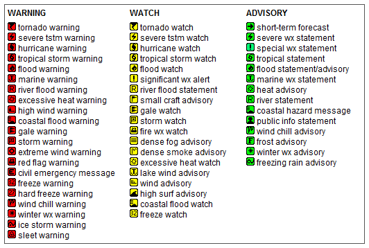
Key to Icons for Local & Regional Weather Statements, Watches And Warnings
Map of the Current Watches, Warnings, and Advisories Nationwide:

|
|
Member of the:

|
North Valley Random Weather Facts |
RECORD COLD TEMPS Hawley Lake recorded Arizona's coldest
temperature of 40° below zero on January 7, 1971. The coldest temperature recorded in
Phoenix was 16°, set on January 7, 1913. Phoenix Sky Harbor Airport, where the
official temperature for Phoenix is recorded, rarely gets below freezing(32°F).
Get the Facts PHP
|
|
Page layout last updated on Mar 8th, 2024
|
|
|