Welcome to the Pepper Ridge North Valley's
Severe Weather Page
This is your weather warning resource page. Check this page for the latest watches and warning updates,
from The National Weather Service, Phoenix, Az.!
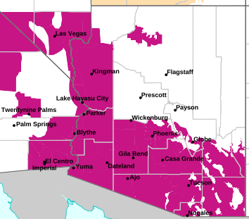
MAP OF CURRENT SOUTHWEST WATCHES, WARNINGS AND ADVISORIES
Local & Regional Weather Statements, Watches And Warnings
Weather Alerts for Central/North PhoenixIssued by the National Weather Service |
EXTREME HEAT WARNING  |
| CENTRAL/NORTH PHOENIX |
Areas Affected: Aguila Valley - Tonopah Desert - Gila Bend - Cave Creek/New River - Fountain Hills/East Mesa - Northwest Pinal County - West Pinal County - Apache Junction/Gold Canyon - Sonoran Desert Natl Monument |
| Effective: Thu, 8/6 11:48am |
Updated: Thu, 8/6 2:14pm |
Urgency: Expected |
| Expires: Fri, 8/7 3:30am |
Severity: Severe |
Certainty: Likely |
|
Details:
* WHAT...Dangerously hot and humid conditions. Afternoon temperatures
106 to 116 degrees. Major Heat Risk.
* WHERE...Portions of Maricopa and Northern Pinal counties
* WHEN...Until 8 PM MST Sunday.
* IMPACTS...Heat related illnesses increase significantly during
extreme heat events. Overexposure can cause heat cramps and heat
exhaustion to develop and, without intervention, can lead to heat
stroke.
* ADDITIONAL DETAILS...In Maricopa County, Call 2-1-1 to find a free
cooling center, transportation, water and more.
https://www.maricopa.gov/heat
Information:
An Extreme Heat Warning means that a period of very hot temperatures,
even by local standards, will occur. Actions should be taken to
lessen the impact of the extreme heat.
Take extra precautions if you work or spend time outside. When
possible, reschedule strenuous activities to early morning or
evening. Know the signs and symptoms of heat exhaustion and heat
stroke. Wear lightweight and loose-fitting clothing when possible and
drink plenty of water.
To reduce risk during outdoor work, the Occupational Safety and
Health Administration recommends scheduling frequent rest breaks in
shaded or air conditioned environments. Anyone overcome by heat
should be moved to a cool and shaded location. Heat stroke is an
emergency! Call 9 1 1.
Public cooling shelters are available in some areas. Consult county
officials for more details. |
EXTREME HEAT WARNING  |
| CENTRAL/NORTH PHOENIX |
Areas Affected: Northwest Valley - Buckeye/Avondale - Deer Valley - Central Phoenix - North Phoenix/Glendale - Scottsdale/Paradise Valley - East Valley - South Mountain/Ahwatukee - Southeast Valley/Queen Creek |
| Effective: Thu, 8/6 11:48am |
Updated: Thu, 8/6 2:14pm |
Urgency: Expected |
| Expires: Fri, 8/7 3:30am |
Severity: Severe |
Certainty: Likely |
|
Details:
* WHAT...Dangerously hot and humid conditions. Afternoon temperatures
108 to 114 degrees. Major Heat Risk.
* WHERE...The Phoenix metropolitan area.
* WHEN...Until 8 PM MST Sunday.
* IMPACTS...Heat related illnesses increase significantly during
extreme heat events. Overexposure can cause heat cramps and heat
exhaustion to develop and, without intervention, can lead to heat
stroke.
* ADDITIONAL DETAILS...In Maricopa County, Call 2-1-1 to find a free
cooling center, transportation, water and more.
https://www.maricopa.gov/heat
Information:
An Extreme Heat Warning means that a period of very hot temperatures,
even by local standards, will occur. Actions should be taken to
lessen the impact of the extreme heat.
Take extra precautions if you work or spend time outside. When
possible, reschedule strenuous activities to early morning or
evening. Know the signs and symptoms of heat exhaustion and heat
stroke. Wear lightweight and loose-fitting clothing when possible and
drink plenty of water.
To reduce risk during outdoor work, the Occupational Safety and
Health Administration recommends scheduling frequent rest breaks in
shaded or air conditioned environments. Anyone overcome by heat
should be moved to a cool and shaded location. Heat stroke is an
emergency! Call 9 1 1.
Public cooling shelters are available in some areas. Consult county
officials for more details. |
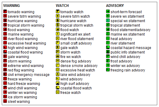
Key to Icons for Local & Regional Weather Statements, Watches And Warnings
Map of the Current Watches, Warnings, and Advisories Nationwide:

|
|
Member of the:

|
North Valley Random Weather Facts |
DEW POINT
Dew point is the temperature to which air must be cooled for saturation (100% relative humidity) to occur. The dew point is an important measurement used to predict the formation of dew, frost, and fog. If dew point and temperature are close together in the late afternoon when the air begins to turn colder, fog is likely during the night. Dew point is also a good indicator of the air's actual water vapor content, unlike relative humidity, which takes the air's temperature into account. High dew point indicates high vapor content; low dew point indicates low vapor content. In addition a high dew point indicates a better chance of rain and severe thunderstorms. You can even use dew point to predict the minimum overnight temperature. Provided no fronts or other weather pattern changes are expected overnight, the afternoon's dew point gives you an idea of what minimum temperature to expect overnight.
Get the Facts PHP
|
|
Page layout last updated on Mar 8th, 2024
|
|
|