ALOHA! Welcome to Paradise!
Enjoy These Photos from Hawaii - Click on picture for full Size View!
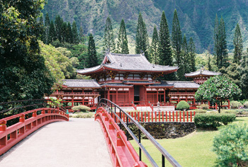
Byodo-In Temple in Kãne‘ohe - Oahu, Hi
| |

Makapu'u Point Lighthouse - Oahu, Hi
|
All Photos are © 2005- 2024 by J. Summers & The Pepper Ridge North Valley Weather Station
All rights reserved. Unauthorized duplication or distribution is prohibited
|
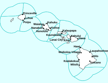
Current Reported Weather Advisiories for Oahu's Eastern Windward Shores
Map of Current Active Hawaii Watches,
Warnings and Advisories
Weather Alerts for Waianae Coast & Mtns, OahuIssued by the National Weather Service |
 HIGH SURF WARNING HIGH SURF WARNING |
| WAIANAE COAST & MTNS, OAHU |
Areas Affected:
Niihau - Kauai Southwest - Waianae Coast - Kahoolawe - Maui Leeward West - Kona - Kohala - Kauai South - East Honolulu - Honolulu Metro - Ewa Plain - Molokai Southeast - Molokai Leeward South - Lanai Leeward - Lanai South - Maui Central Valley South - Kipahulu - South Maui/Upcountry - South Haleakala - Big Island South - Big Island Southeast |
| Effective: Sun, 6/14 3:34pm |
Updated: Sun, 6/14 11:06pm |
Urgency: Expected |
| Expires: Mon, 6/15 5:00am |
Severity: Moderate |
Certainty: Likely |
|
Details:
...HIGH SURF WARNING FOR SOUTH FACING SHORES OF ALL HAWAIIAN
ISLANDS THROUGH TUESDAY MORNING...
...COASTAL FLOODING DURING HIGH TIDES THROUGH TUESDAY...

.The combination of a large long-period south-southwest
(200 degree) swell and King Tides will cause significant wave up
and could cause widespread coastal flooding during the afternoon
high tides along south facing shores. Also due to the highest
monthly tides and water levels running higher than predicted at
select areas, flooding along all shorelines and in low-lying
coastal areas are expected especially during the late afternoon
and early evening hours.

* WHAT...For the High Surf Warning, dangerously large breaking
waves of 10 to 15 feet. Significant wave run up expected
during the peak high tide during the afternoons. For the
Coastal Flood Statement, isolated minor coastal flooding.

* WHERE...South facing shores of all Hawaiian Islands.
Vulnerable low-lying coastal roadways, docks, boat ramps and
other coastal infrastructure.

* WHEN...For the High Surf Warning, until 6 AM HST Tuesday. For
the Coastal Flood Statement, through Tuesday afternoon.

* IMPACTS...High. Expect very strong breaking waves and powerful
currents. Waves breaking in channel entrances may make
navigating the channels dangerous. Flooding of beaches that
are normally dry, minor coastal erosion, and saltwater
inundation.

* ADDITIONAL DETAILS...The combination of the south-southwest
swell and King Tides over the next couple of days will result
in more widespread coastal shore impacts, particularly during
the afternoon and evening peak daily tide.
Information:
Avoid driving through flooded roadways. If you are forced to
drive through salt water, be sure to rinse your vehicle with
fresh water. Move electronics, vehicles or other valuables to
higher ground. Monitor vessels to ensure mooring lines don't get
too tight and watch out for overwash around boat ramps. Secure
canoes or other watercraft stowed on beaches.

Stay away from the shoreline along the affected coasts. Be
prepared for road closures. Postpone entering or leaving channels
affected by the high surf until the surf subsides. |
 COASTAL FLOOD STATEMENT COASTAL FLOOD STATEMENT |
| WAIANAE COAST & MTNS, OAHU |
Areas Affected:
Niihau - Kauai Southwest - Waianae Coast - Kahoolawe - Maui Leeward West - Kona - Kohala - Kauai South - East Honolulu - Honolulu Metro - Ewa Plain - Molokai Southeast - Molokai Leeward South - Lanai Leeward - Lanai South - Maui Central Valley South - Kipahulu - South Maui/Upcountry - South Haleakala - Big Island South - Big Island Southeast |
| Effective: Sun, 6/14 3:34pm |
Updated: Sun, 6/14 11:06pm |
Urgency: Expected |
| Expires: Mon, 6/15 5:00am |
Severity: Minor |
Certainty: Likely |
|
Details:
...HIGH SURF WARNING FOR SOUTH FACING SHORES OF ALL HAWAIIAN
ISLANDS THROUGH TUESDAY MORNING...
...COASTAL FLOODING DURING HIGH TIDES THROUGH TUESDAY...

.The combination of a large long-period south-southwest
(200 degree) swell and King Tides will cause significant wave up
and could cause widespread coastal flooding during the afternoon
high tides along south facing shores. Also due to the highest
monthly tides and water levels running higher than predicted at
select areas, flooding along all shorelines and in low-lying
coastal areas are expected especially during the late afternoon
and early evening hours.

* WHAT...For the High Surf Warning, dangerously large breaking
waves of 10 to 15 feet. Significant wave run up expected
during the peak high tide during the afternoons. For the
Coastal Flood Statement, isolated minor coastal flooding.

* WHERE...South facing shores of all Hawaiian Islands.
Vulnerable low-lying coastal roadways, docks, boat ramps and
other coastal infrastructure.

* WHEN...For the High Surf Warning, until 6 AM HST Tuesday. For
the Coastal Flood Statement, through Tuesday afternoon.

* IMPACTS...High. Expect very strong breaking waves and powerful
currents. Waves breaking in channel entrances may make
navigating the channels dangerous. Flooding of beaches that
are normally dry, minor coastal erosion, and saltwater
inundation.

* ADDITIONAL DETAILS...The combination of the south-southwest
swell and King Tides over the next couple of days will result
in more widespread coastal shore impacts, particularly during
the afternoon and evening peak daily tide.
Information:
Avoid driving through flooded roadways. If you are forced to
drive through salt water, be sure to rinse your vehicle with
fresh water. Move electronics, vehicles or other valuables to
higher ground. Monitor vessels to ensure mooring lines don't get
too tight and watch out for overwash around boat ramps. Secure
canoes or other watercraft stowed on beaches.

Stay away from the shoreline along the affected coasts. Be
prepared for road closures. Postpone entering or leaving channels
affected by the high surf until the surf subsides. |
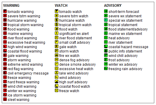
Key to Warnings, Watches and Advisories Icons:
Map of the Current Watches, Warnings, and Advisories Nationwide:

|
|
Kãne‘ohe and Kãne‘ohe Bay with the Koolau Mountains as backdrop - Windward - Oahu, Hawaii
|
Member of the:


|
Pepper Ridge North Valley Random Weather Facts |
MOON PHASE Misconception...
"The most common incorrect reason given for the cause of the Moon's phases is that we are seeing the shadow of the Earth on the Moon! But this cannot be correct: when the Moon passes through the shadow of the Earth, we get a lunar eclipse. Anyone who has seen a lunar eclipse, though, might remember that the Moon actually passes through the Earth's shadow only rarely, so that can't be why the Moon has phases. The real reason for the Moon's phases depends on two things: the Moon is round, and the angle it makes with the Earth and Sun changes over its orbit."
- As Quoted From Bad Astronomy.
Get the Facts PHP
|
|
Page layout last updated on March 25th, 2024
|

 New Feature


